
Compass, sundial, qibla indicator
BackDescription:
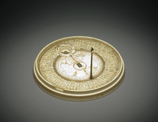
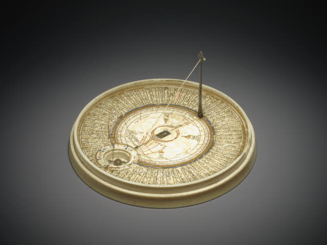
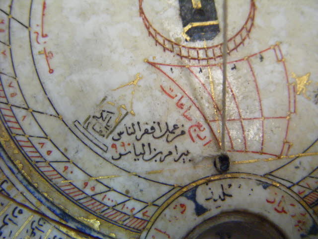
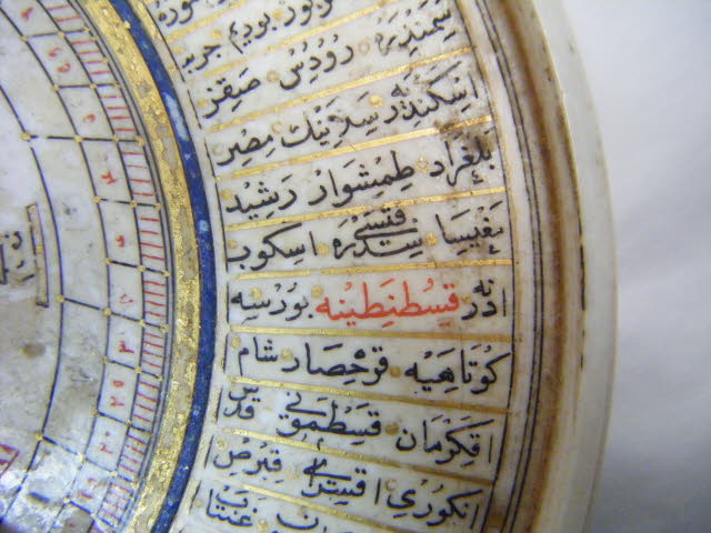
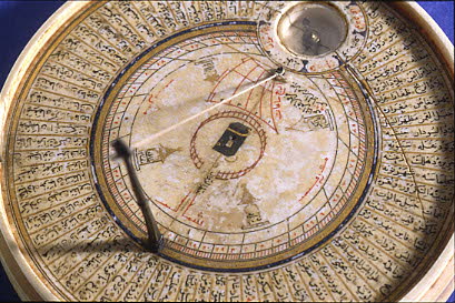
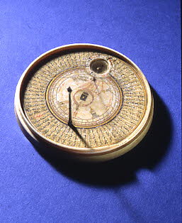
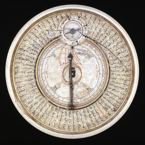
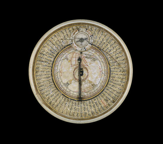
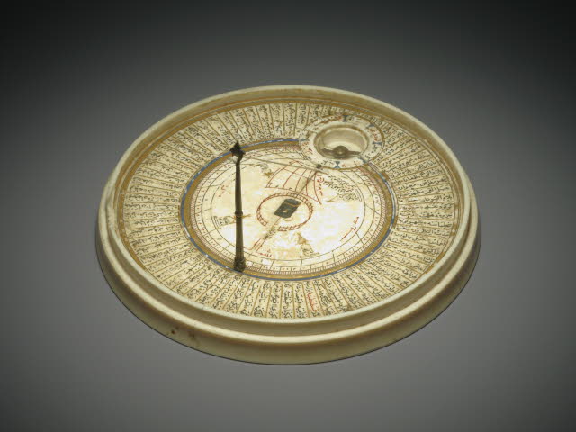
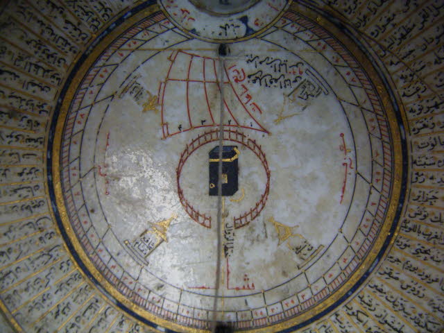
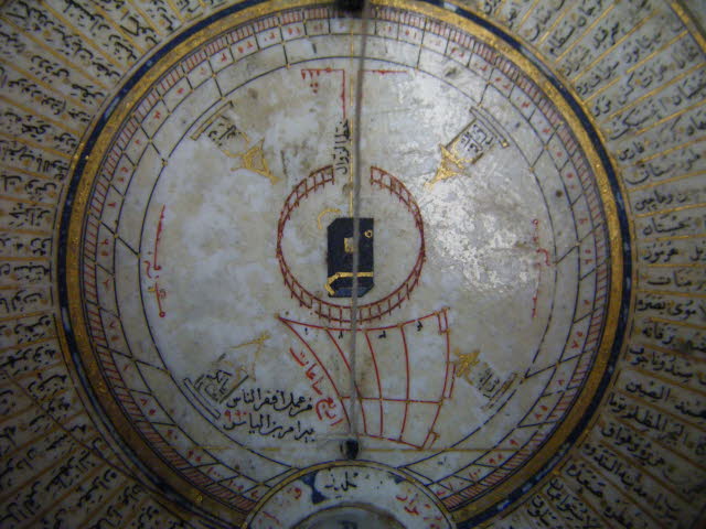
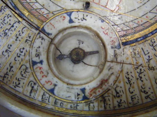
Ivory qibla indicator and horizontal sundial, with a depiction of the Ka’ba in the centre. Constructed for the latitude of Istanbul, this ivory qibla indicator and horizontal sundial is one of the more unusual examples of instruments made for finding the direction of Mecca. It consists of a flat circular box with a loose lid, both mostly plain on the outside with the exception of a gold stylized flower with eight petals in the centre of the outside of the lid. The centre of the flower appears to be missing an inlay. The ivory is cracked and chipped in various places. The inside of the main box is laid out in various concentric circles, separated from each other by gold and blue. In the centre is a schematic depiction of the Ka’ba in black and gold, surrounded by a red fence. A line drawn in gold from north to south intersecting with the fence and the Ka’ba is labelled in black khatṭ̣ ̣al-zawāl (meridian line). The red sail-shaped feature between the Ka’ba and a small compass in the upper part of the instrument is a sundial that enables the user to find the time of the ‘asr prayer in the afternoon. It is labelled 1 to 4 in Arabic numerals (١, ٢, ٣ and ٤) and is laid out in so-called ‘unequal hours’ (that is the length of daylight between sunrise and sunset divided into twelve parts whose length changes over the course of the year). To the right of the first hour curve is a red inscription arba’a sā’āt (= four hours, i.e. before the ‘asr prayer). Next to this is black signature في(؟) عمل افقر الناس fī (?)’amal afqar al-nās Bayrām Ibn Ilyās ((unclear) work of the most humble Bayrām Ibn Ilyās) and the date of production 990 AH (= 1582/3 AD) in red. The circle around the compass well is divided into eight sectors by blue stylized pillars. The sectors are labelled alternating in red and black words which have yet to be identified - they may be compass directions or wind names. The glass and needle are intact and appear to be original. The outermost circle along the rim is divided into 72 sectors that give the names of cities and regions in the Islamic World, all written in black with the exception of Qustantinīa (Istanbul) which is written in red. Each sector contains at least two, often more names, separated from each other by gold dots. Further to the inside is a horizontal sundial laid out with a degree scale starting from 0 in either direction from a point at the foot of a foldable metal strut. The scale is labelled in Arabic numerals every five degrees and subdivided into single degrees and runs up to 105 degrees on either side; the remaining scales are overlaid with the circular inscription around the compass well. Further to the inside is another circle divided into sectors that correspond to 15-degree sections on the outer circle. These are divided by black lines with the exception of the sectors starting at 90 degrees on either side along which a gold line is drawn, but not labelled. The markings within these sectors, presumably hours, are now too rubbed off to be deciphered. A string gnomon, which is attached to the tip of the foldable metal strut and threaded through a hole in the ivory just below the compass, casts a shadow that enables both sundials (i.e. the circular horizontal sundial and the sail-shaped dial between the drawing of the Ka’ba and the compass), to be used in conjunction. The angle of the string gnomon indicates an underlying latitude of 41 degrees North, which corresponds to Istanbul. Furthest to the inside, along the markings for the horizontal sundial four stylized mihrabs are drawn in gold to indicate the places of prayer (maqām) for the four schools of Islamic law, Shafi’i, Maliki, Hanbali and Sharafi and are labelled as such. The four cardinal directions are given in red.
Object type: | compass, sundial, qibla indicator |
Museum number: | 1921,0625.1 |
Culture/period: | Islamic |
Date: | 1582-1583 (990 AH) |
Findspot: | Found/Acquired: Cairo |
Materials: | ivory, brass (?), gold, metal (strut), fibre (string) |
Dimensions: | Diameter: 11.00 cm Height: 1.80 cm (overall, box closed) Height: 1.30 cm (box without lid) Height: 5.50 cm (box with metal strut unfolded) |
Inscriptions: | Inscription details: signature and date (Between the sail-shaped dial and compass well) in Arabic in naskh script Inscription quoted: في(؟) عمل افقر الناس بيرام بن الياس ٩٩۰ Inscription transliteration: fī (?)’amal afqar al-nās Bayrām Ibn Ilyās 990 Inscription translation: from (?) the work of the most humble Bayrām Ibn Ilyās 990 Inscription: Inscription details: inscription (In red in the list of cities and places) in Arabic in naskh script Inscription quoted: قصطنطنيّة Inscription transliteration: Qustantinia Inscription translation: Constantinople (Istanbul) Inscription note: The place for which this sundial was constructed, as confirmed by the angle of the gnomon. |
Location: | 25 |
Exhibition history: | Exhibited: 2017-2018 2 Nov-8 Apr, BM Gallery 35, Living with gods 2014 22 Apr-10 Aug, Paris, Institute du Monde Arabe, 'Hajj, the pilgrimage to Mecca' 2013-2014 9 Sep-19 Mar, Leiden, Rijkmuseum Volkenkunde, Longing for Mecca a pilgrim's journey 2012 26 Jan - 15 Apr, London, BM, 'Hajj: journey to the heart of Islam' 1999 1 Dec-2000 24 Sep, London, The Queen’s House, The Story of Time |
Acquisition names: | Purchased from: Abd al-Ghany Shehab |
Acquisition date: | 1921 |
Curator's comments:
How to use the instrument To use the sundial one first needs to set the instrument on a flat surface and rotate it until the needle on the compass is correctly aligned in a north-south direction. When the metal pin is due north then the string is properly aligned towards the north-pole and the sundial will indicate the correct time – but only for the latitude for which it was constructed, namely 41 degrees North, that is, for example, Istanbul. To use the qibla indicator it might be easiest to imagine the dial of a clock 1 to 12 on the outside of the rim. The foot of the metal pin is at 12o’clock. The places listed between 12o’clock and 3pm are all roughly north-east of Mecca (the closer to 12 the more northerly, the closer to 3 the more easterly) and thus have a general qibla direction of south-west (again, the closer to 12 the more southerly, the closer to 3 the more westerly). This is not an accurate ‘map’ but an approximation, where places that are in the same area (and thus with roughly the same qibla) are grouped together. To use the qibla indicator from a certain place one would first identify that place in the list and its position in relation to the Ka’ba in the centre. Then one would align the instrument in a north-south direction with the help of the compass and determine the approximate direction of the Ka’ba.; For in-depth informtation on qibla indicators see David A. King, World-Maps for Finding the Direction and Distance to Mecca. Innovation and Tradition in Islamic Science. Brill: 1999, p. 117 figure 2.9.12 with caption on p. 116. On Sacred Geography ibidem, pp. 51-5. On gezeters on instruments with qibla-values for different locations ibidem, pp. 87-89.
1 of 12